Science Corner
WRWP is committed to the scientific method of observation and testing. We work closely with the scientific community, the MDEQ, MiCorps (Michigan Clean Water Corps), NOAA (National Oceana and Atmospheric Administration), AWRI (Annis Water Resources Institute, GVSU) and other agencies to ensure we are doing our absolute best to protect the watershed and be proactive in its care.
Choose a link below to learn more about the watershed, its ecological challenges such as invasive species, as well as the projects the Partnership has undertaken to preserve this beautiful and critically important natural resource.
EnviroDIY Provides Early Warning
for Cold Water Game Fish
The White River and its tributaries form the southernmost watershed in Michigan that significant numbers of cold water game fish such as trout and salmon call home. In this respect, the White River is the proverbial canary in the coal mine for adverse effects of a warming climate. A changing climate threatens these fish, so WRWP has begun to actively record data that will help document changes to this critical coldwater habitat.
With technical backstopping and financial assistance from Trout Unlimited, the Partnership is now overseeing the operation of two remote sensing stations. Additional deployments are planned. These devises will enable WRWP to establish baseline data at the monitoring sites. As
the stations collect data in real time, they provide an early warning
system for both natural and man-made perils throughout the watershed. Long term, the project will establish a monitoring network in the portions of the watershed which are deemed critical for healthy aquatic macroinvertebrates and resident and migrating saltwater salmonids.
WRWP Board chair Ray Schinler hopes wide-spread access to this information will compel fishermen to impose voluntary moratoriums when needed on trout fishing during times when the fish are particularly stressed by high stream temperatures or adversely low flows. These self-imposed moratoriums are routinely used on other Michigan rivers, such as the Muskegon, AuSable and Pere Marquette. Schinler says this data will also be useful to the Fisheries Division when make fish stocking decisions, such as the potential introduction of Atlantic Salmon below Hesperia, or the reintroduction of Arctic Grayling.
EnviroDIY - the remote sensing devices - use a cellphone link to transmit data to an online archive from sensor arrays deployed in the stream. A solar panel supplies operational power and recharges back-up batteries. Although the stations work with a variety of sensors, WRWP is using its units to measure water temperature, depth and electrical conductivity; readings are taken continuously at 15-minute intervals.
Water temperature is a critical factor affecting biological activity for aquatics. It is especially critical for spawning activity by coldwater species such as trout and salmon where temperatures between 50⁰-65⁰F are optimal. When streams become too warm, they forfeit the ability to support populations of desirable coldwater game fish.
EnviroDIY also measures water depth, which fluctuates based on input from rain and snowmelt, and in some cases, water withdrawals. Records of river and stream depths over time help mark the severity of extreme conditions such as floods and droughts.
Electrical conductivity reflects the concentration of chemicals influencing the water's ability to conduct electrical charge. An indirect measure of the saltiness of water, measuring conductivity is important to both fish and macroinvertebrates. Since they breathe through their gills, skin or another organ, osmosis either pushes water into, or pulls water out of their bodies. Freshwater animals regulate the amount of water going in and out of their bodies in
part by drinking less water and producing dilute urine. Life for them is a balancing act of either excreting or absorbing water to maintain the proper concentration of body fluids. Conductivity exceeding their adaptive ranges, either above or below, will stress, interfere with reproduction, or kill them.
Freshwater streams with healthy fish populations generally exhibit conductivity ranging from 150-800 microSiemens/centimeter. Since groundwater typically contains greater levels of charge-carrying chemicals than rainwater, conductivity is higher when most of the stream's water comes from the ground, and falls during run-off events. Fluctuations can also be traced to inputs from road salt run-off and water softener backwash.
Ocean water conductivity is around 50,000 microSiemens/centimeter. White River's North Branch, an excellent stretch of cold-water stream, has a long-term average conductivity of about 350 microSiemens/centimeter, with lower values recorded following heavy rains, as expected.
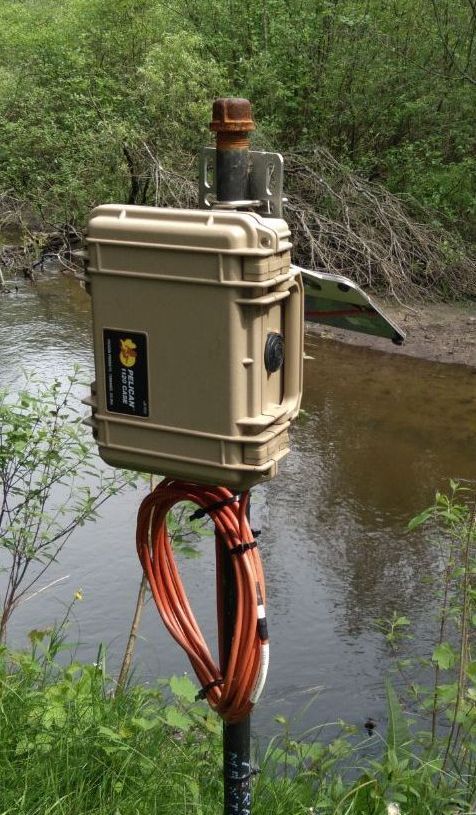
Completed installation of a streamside EnviroDIY module. This sensor - formerly known as Mayfly - is one of two installed in White River. WRWP is working
to established a sensor network at critical locations throughout the watershed.
.jpeg)
Signal acquisition, processing and transmission components in the EnviroDIY solar-powered sensors.
.jpg)
This EnviroDIY sensor will record temperature, water depth and conductivity in the White River watershed. Sensors have been installed in the North Branch of the White, just above its confluence with Cobmoosa Creek, and in Carlton Creek below Arthur Road.